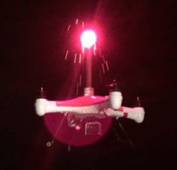
A Splash Drone, outfitted with a burning flare or fusee spitting out hot slag and sparks.
As if wildand fire managers didn’t have enough to worry about when it comes to drones invading the air space above fires and possibly causing a mid-air collision with a firefighting aircraft, now a drone is going into production that can carry a burning emergency flare, known to firefighters as fusees.
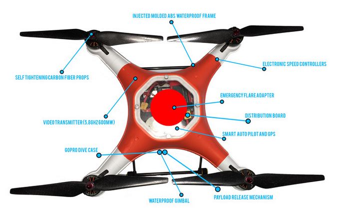
The Splash Drone has received over $51,000 toward their $17,500 goal on Kickstarter. It is expected to begin shipping in July or August of this year.
The “Splash” part of the name is derived from the fact that it is designed to be waterproof. A video shows it being thrown into the water and then taking off. Another interesting feature is that it has a payload release mechanism, and in that same video it drops a bottle of water. We can picture a firefighter rigging it to drop water from a container, suppressing a fire that’s about three inches square.
The worrisome part is the adapter on the top into which you can....Continue Reading
insert a burning fusee. The video explains the need for that feature:
It allows you to deploy an emergency flare for 15 minutes rather than 15 seconds.
There is no release mechanism for the fusee mounted on top, but when they burn they drop hot slag that can start fires. Or, a twisted arsonist could attach a fusee to the release mechanism on the bottom, and create havoc. A person has to wonder what the dripping hot slag will do to the drone. They say it’s waterproof, but the term “fireproof” is not mentioned.
Another use for the the fusee mount could be to carry a flag. A squadron of five or more drones could then do a flag flyover before a football game or NASCAR race. Of course the first time they crash into the crowd would be the end of that style of patriotic tribute.
Splash drone. (Click to enlarge.)
On Kickstarter the price begins at $399 for a very basic “DIY kit” and goes all the way up to $1,999 for an assembled drone with a bunch of accessories and a “personal 6-hour flight lesson”.
There is no question that Unmanned Aerial Systems (UAS) could provide wildland firefighters with valuable real time intelligence. The biggest hurdle that has to be overcome is how to safely integrate them into the airspace above a fire. For incidents with a Temporary Flight Restriction could they be assigned an altitude above all other firefighting aircraft, or should they be restricted to night operations when no other aircraft are working on the fire?
Firefighters in Western Australia have started to use an Indago UAS built by Lockheed Martin. Today the company released information about how it is being utilized.
Western Australia’s Emergency Services Commissioner called upon Lockheed Martin’s Indago quad copterto assist with efforts to contain and extinguish a fire that had the potential to threaten lives and property.
In its first real-world firefighting tasking, the aircraft flew over the live fire and provided real-time intelligence to the Planning and Incident Management team. The Indago was able to provide information on the location of the fire edge, the intensity and location of hotspots, as well as identify people and assets at risk through smoke. The Indago also assessed damage and transmitted real-time images of activities occurring on the ground.
“After Indago’s insertion into our firefighting operations, an estimated 100 homes were saved,” said Wayne Gregson, Fire and Emergency Services Commissioner. “The Indago provided a critical capability while the manned aircraft were grounded at nightfall, and increased our ground operators’ situational awareness.”
For more than 80 years, manned aircraft have been employed in support of ground firefighting operations; currently, aircraft support is available to ground firefighters in Australia for approximately 12-14 hours per day during daylight hours only.
“The Indago can work to fight fires and provide information to operations day and night without risking a life,” said Dan Spoor, vice president of Aviation and Unmanned Systems at Lockheed Martin’s Mission Systems and Training business. “This real world application signifies the potential for using unmanned systems to augment manned firefighting operations, doubling the amount of time for fire suppression.”
The Indago’s industry-leading flight time and EO/IR gimbaled imager provides high quality data and enhanced situational awareness for operators to make real-time decisions. Indago is capable of providing tactical situational awareness and geo-location, increasing its value in missions such as firefighting.
“The Indago has shown its ability to operate in all weather and visibility conditions,” said Tim Hand, Chief UAV Controller at Heliwest. “Since we began using it in November 2014, it has performed well in temperatures ranging from -12 degrees to 112 degrees; rain to snow; and smoke or dust.”
The Heliwest Group, which is providing aircraft and services in support of the firefighting mission, first took delivery of the Indago in November 2014; since then, Heliwest has flown the Indago more than 200 hours in support of multiple civil operations including firefighting, task inspections and surveying.
The United States and Australian governments will be developing additional regulations for Unmanned Aerial Systems (UAS), or drones. With the entry price of around $500 without a camera, the number of these things in the air is increasing substantially. It is a pretty safe bet that many people found one under their Christmas tree this year. Drones have already created problems on wildfires in both countries.
The PBS News Hour recently covered the subject, indicating that Congress will develop their own rules, in lieu of the FAA’s failure to develop anything substantial so far:
… “That appears to be what some key lawmakers have in mind. “We in Congress are very interested in UAS,” Rep. Bill Shuster, R-Pa., chairman of the House Transportation and Infrastructure Committee, said at a hearing this month, referring to unmanned aerial systems, or drones. “We understand UAS are an exciting technology with the potential to transform parts of our economy. … It is our responsibility to take a close look.”
One of the committee’s first priorities next year is writing legislation to reauthorize FAA programs and overhaul aviation policy. The bill is expected to include directions from lawmakers on how to integrate drones into the nation’s aviation system. The last reauthorization bill, passed in 2012, directed the agency to integrate drones by Sept. 30, 2015, but it’s clear the FAA will miss that deadline.”…
Now Congress is going to provide directions on how to operate UAS’s in the National Airspace …
A scary thought — Congress developing aviation rules.
Below are excerpts from Queensland Country Life about how Australia plans to deal with the proliferation of UAS:
AUSTRALIA is set to have among the world’s toughest rules on drones after the Civil Aviation and Safety Authority (CASA) rewrites its regulations in the new year.
CASA spokesman Peter Gibson said the “huge growth” in popularity of the flying “unmanned aerial vehicles” – which are helicopter-like craft, with GPS and cameras – meant regulations had to be “updated”.
At the moment drones for commercial use by police, fire services, aerial photographers and in some agricultural settings are regulated by CASA. Commercial users – there are 180 in Australia, a jump on only 34 in 2013 – need a licence. But recreational users do not.
Mr Gibson said drones must be kept more than 30 metres away from other people and must not be flown over crowds of people at beaches or sporting events.
Drones can only be operated in daylight where the operator can see them, should be kept more than 5 kilometres from airports and be flown below 121 metres.
Infringement notices can be issued if these regulations are broken. Prosecutions can be enforced if anyone is injured.
Late last year CASA struck a deal with a big drone manufacturer, DJI Phantom, in China, to insert written guidelines in the boxes. This follows incidents of drones being flown over bushfires and crime scenes to capture video and photographs. In October 2013 a drone flew over a bushfire near Sydney, forcing emergency services to ground firefighting aircraft.
A man who flew a drone at the scene of a siege at Altona North in Victoria two weeks ago will be fined $850. The drone crashed into a power line and fell, nearly hitting a police officer. In June a drone narrowly missed a rescue helicopter in Newcastle. It was flying at nearly 300 metres.
We heard from Dick who said:
Retired USFS Smokejumper and Pilot Willis Curdy from Missoula starts Monday [January 5, 2015] as a member of the Montana House. He’ll introduce legislation limiting drones.
A privately operated drone (or unmanned aerial vehicle) caused concern on the Sand Fire south of Placerville, California on Sunday. The person that was controlling the aircraft and getting video footage of the blaze was told by authorities to stop because of the potential danger to helicopters, lead planes, and air tankers flying over the fire.
A video shot from the drone was uploaded to YouTube showing that the aircraft was directly over the fire, which could have been a serious hazard to helicopters and air tankers operating at 50 to 180 feet above the ground.
There are reports that Air Attack, when informed of the drone, came close to grounding all firefighting aircraft until the threat could be mitigated. However the operator was found and instead, the drone was grounded.
Last month the U.S. Forest Service and the Department of the Interior issued an Interagency Aviation Safety Alert about the hazards of unmanned aerial vehicles operating near wildfires.
Last year the U.S. Forest Service had eight K-MAX helicopters under exclusive use contract to help suppress wildfires. Lockheed Martin configured unmanned K-MAXs to deliver thousands of loads of supplies and equipment to soldiers in Afghanistan between 2011 and 2014, carrying more than 4.5 million pounds of cargo, sometimes through areas that would be considered unacceptably risky for human pilots.
On November 6, 2014 a team of Lockheed Martin and Kaman unmanned aircraft demonstrated its ability to aid in firefighting operations. During the demonstration, the remote controlled Indago quad rotor effectively identified hot spots and provided data to an operator who directed the unmanned K-MAX helicopter to autonomously extinguish the flames.
In one hour, the unmanned K-MAX helicopter lifted and dropped approximately 3,000 gallons of water onto the fire. A Skycrane could almost do that in one drop. This seems like a small amount of water for the K-MAX and appears to be about five drops, after dipping water from a nearby pond. Usually the K-MAX can carry about 680 gallons, not quite meeting the minimum capacity of 700 gallons for a Type 1 helicopter.
“The unmanned K-MAX and Indago aircraft can work to fight fires day and night, in all weather, reaching dangerous areas without risking a life,” said Dan Spoor, vice president of Aviation and Unmanned Systems at Lockheed Martin’s Mission Systems and Training business.
“This demonstration signifies the potential for adapting proven unmanned systems and their advanced sensors and mission suites to augment manned firefighting operations, more than doubling the amount of time on station,” said Kaman Chairman, President and Chief Executive Officer Neal Keating.
The K-MAX autonomously dipped water from a pond and delivered it to the fire location. The helicopter was manufactured by Kaman and outfitted with an advanced mission suite by Lockheed Martin. Using its electro-optic/infrared (EO/IR) camera, K-MAX can locate hot spots and designate the location to its operator for water drops at that location. K-MAX has proven the ability to autonomously conduct resupply operations with the capability to deliver to four different locations. Its flexible multi-hook carousel is suited for attachments such as water buckets, litters and medical supplies.
K-MAX manned helicopter at Custer (South Dakota) Airport, July 10, 2012, Photo by Bill Gabbert.
NASA researcher Mike Logan plans to use this small unmanned aerial vehicle to detect fires at the Great Dismal Swamp Wildlife Refuge in Virginia and North Carolina as part of an agreement with the U.S. Fish and Wildlife Service. Photo by David C. Bowman of NASA Langley.
In November we ran a story about how Mike Logan, an aerospace engineer at NASA’s Langley Research Center, put a group of students to work designing and building an Unmanned Aerial Vehicle (UAV) that could help to detect wildfires in Virginia’s Great Dismal Swamp. Now Mr. Logan has another UAV that has a range of about eight miles which can stay aloft for an hour before the batteries need recharging.
From NASA:
****
NASA’s research in unmanned aerial systems (UAS) may soon provide a means for early detection and mitigation of fires in the Great Dismal Swamp National Wildlife Refuge, a nearly 50,000-square-acre region centered on the Virginia-North Carolina border.
NASA’s Langley Research Center, in nearby Hampton, Virginia, has signed a one-year agreement with the Department of the Interior’s U.S. Fish and Wildlife Service (FWS) to test small UASs for the detection of brush and forest fires. The research is part of the NASA Aeronautics Research Mission Directorate’s UAS Integration in the National Airspace System (NAS) project.
“The U.S. Fish and Wildlife Service is evaluating the feasibility of airborne unmanned platforms and their ability to offer a safer and more cost-effective alternative for surveillance of potential areas of interest immediately following thunderstorm activity,” said Great Dismal Swamp Refuge Manager Chris Lowie. “The agency hopes to see a significant decrease in cost to survey the Great Dismal Swamp, as well as a reduction in time to detect nascent fires, which could potentially save millions of dollars to the taxpayer in firefighting costs,” added Lowie.
Mike Logan, the research lead at Langley, came up with the idea after a forest fire in 2011 that lasted almost four months and cost more than $10 million to extinguish. Smoke from that fire, which was caused by a lightning strike, traveled as far north as Maryland only three years after another $10-million blaze in 2008, according to FWS.
“I made a phone call to the local fire captain after days of inhaling peat bog smoke,” said Logan. “I learned most fires are caused by lightning strikes and the only way they can spot them is by hiring an aircraft to do an aerial survey of the huge swamp. So I figured why not use a UAV as a fire detector?”
After approval from the Federal Aviation Administration, the team at Langley plans to fly a lightweight UAS equipped with cameras and transmitters over the wildlife refuge.
“One is an out-of-the-nose camera that can see smoke plumes as they are rising,” Logan explained. “The other is an infrared camera housed in the body of the plane that points down. It can find hot spots by detecting heat signatures.”
Although the aircraft can fly as fast as 40 miles an hour, when used in this capacity it will be flown slower while it transmits video, allowing individuals on the ground to observe what is occurring in the live video. The transmissions can be viewed on a laptop computer in a mobile ground station.
Logan says the drone, which weighs about 15 pounds and has an almost six-foot wingspan, has a range of about eight miles and can stay aloft as long as an hour, before the batteries need recharging. The aircraft also can be programmed to fly on its own, but a safety pilot will monitor operations during the tests.
“This kind of application for unmanned aerial systems shows just one public benefit,” said Dave Hinton, Langley associate director for UAS technologies and applications. “They can be used to detect fires or locate people who are lost.”
State forestry departments in Washington and Oregon had hoped to try out drones this summer to provide reconnaissance at wildfire scenes. But neither firefighting agency managed to pull it off. Now both plan to try again next year.
State foresters in southern Oregon acquired a remote-controlled helicopter at the beginning of fire season, but discovered they couldn’t legally fly it without pilot’s licenses. The training and paperwork are now in progress.
Meanwhile, a leader in the Northwest’s unmanned aircraft industry has launched a separate project to develop a nighttime wildfire reconnaissance capability. Eric Simpkins of Bend, Oregon, said he’s lined up four drone providers willing to donate flight time to demonstrate the new technology for wildfires.
“Fires do change during the night. Winds come up, move the fires a lot,” Simpkins said at an industry conference in Warm Springs, Oregon. “It is very hard for fire managers to know what is going on during hours of darkness and it inhibits their ability to get a quick start the next morning.”
This past July, Washington’s Department of Natural Resources got emergency approval from the Federal Aviation Administration to deploy a drone at a wildfire north of Wenatchee. Boeing subsidiary Insitu provided one of its ScanEagle unmanned aircraft to use for free. But the experiment was scrubbed at the last minute.
A state spokesman says they want to try again next summer on a tamer wildfire.
A privately operated drone (or unmanned aerial vehicle) caused concern on the Sand Fire south of Placerville, California on Sunday. The person that was controlling the aircraft and getting video footage of the blaze was told by authorities to stop because of the potential danger to helicopters, lead planes, and air tankers flying over the fire.
A video shot from the drone was uploaded to YouTube showing that the aircraft was directly over the fire, which could have been a serious hazard to helicopters and air tankers operating at 50 to 180 feet above the ground.
There are reports that Air Attack, when informed of the drone, came close to grounding all firefighting aircraft until the threat could be mitigated. However the operator was found and instead, the drone was grounded.
Last month the U.S. Forest Service and the Department of the Interior issued an Interagency Aviation Safety Alert about the hazards of unmanned aerial vehicles operating near wildfires.
A person would think that a Temporary Flight Restriction (TFR) which was probably in effect over the fire would prohibit all non-authorized aircraft including drones under 400 feet, from operating in the area. If so, then penalties could be applicable. A pilot of an airplane can lose their pilot’s license for 90 days or so if they bust a TFR. Of course a doofus who buys $1,000 worth of drone and does stupid things with it has no license to begin with.
This problem will get worse before it gets better. There will be more and more consumer-grade drones flying around and keeping them out of fire areas is going to be very difficult.
As we have said before, Air Attack needs to live up to its name and be armed with air to air missiles (kidding!). (EDIT: Or, as we said in a comment, some of the Air-Cranes have a front mounted water cannon that could be very effective, non-lethal [except to the drone], and would not start additional fires!)
No drones were harmed in the making of this movie. It was filmed from a DJI Phantom 2 using a GoPro Hero 3 Silver. Be sure and watch it in full screen and 1080p HD.